Drone Inspections
Drone inspections and surveys offer a quicker, more cost-effective and safer alternative to conventional visual inspection.
Drone Inspection
Drone services are transforming visual inspections to critical industrial infrastructure. Drones or Unmanned Aerial Vehicles (UAV’s) can be used wherever visual inspections and surveys are required as part of routine industrial maintenance or monitoring of remote sites
Drones are used at height or in confined spaces to make it possible to access areas that pose risks to health and safety and the environment. Drones (UAVs) also significantly reduce the cost to your business posed by other visual inspection methods.
Unmanned vehicle services are the most efficient and practical way to access and inspect critical onshore and offshore infrastructure. From warehouse roof inspections to offshore oil and gas installations, inspection of power plants and power lines and the visual inspection of onshore and offshore wind turbines.
The goal of visual inspections is to assess if industrial assets meet quality standards or require routine maintenance. In the past, industrial inspectors performed visual inspections using only the naked eye. Inspectors would access hard to reach places using elevated platforms, scaffolding and rope access.
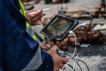
Today, drone inspections and surveys using cameras that record and map assets on-site, allow engineers to review the footage and report their findings from the ground.
A drone inspection can be used for a range of infrastructure. The drone flies close to or throughout the structure, creating a 3D render and map. Once complete, engineers evaluate the results and create an action plan for any necessary maintenance.
Confined Space Drones
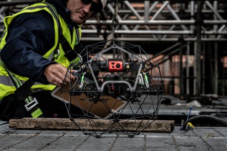
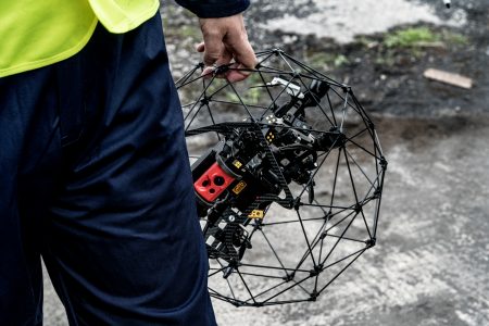
The Flyability Elios 2 is the most intuitive, reliable, and precise indoor inspection drone. Keep your workforce out of harm’s way while performing flawless inspections right from the first flight using cutting edge drone data capture capabilities.
We believe that human intervention into hazardous and dangerous environments should be minimised wherever possible. Reinventing collision-resilience, the Elios 2 allows you to capture every corner and inch of the most complex and confined spaces, from a safe location.
Drone Inspection Services For External Assets:
Buildings, Roofs, Tanks, Turbines, Stacks, Bridges, Rail, Roads, Towers, Land Surveys, Agricultural Surveying, Volumetric Surveying.
Drone Inspection Services Internal Assets:
Confined Spaces, Building Internals, Culverts, Pipelines, Stack Internals, Shafts, Mines, Ballast Tanks, Indoor Stockpiles.
Which Industries use Drone Services?
Drones provide critical visual and thermal data on the operating condition of power stations helping power generation and utility companies improve health and safety by keeping inspectors out of dangerous situations.
Read our power generation case studies:
The oil and gas industry uses drones for a range of tasks including:
- Leak Detection – prior to drones, traditional leak detection methods were costly and inefficient. Oil and gas companies would detect leaks by mounting fixed detectors at high-risk spots in facilities and along pipelines or by having inspectors occasionally check areas with portable detectors.
- Asset maintenance – Drones also allow you to cut down on labour costs and can reduce inspection time by as much as 80%. This means you need fewer workers to work fewer hours. Plus, you save on travel costs associated with bringing in surveyors.
- Optimising operations – Drones can collect a wide range of data about offshore oil and gas production, including flow rates, pressure and temperature readings. This data can help oil and gas producers optimise their operations and improve production efficiency.
Wind and solar farms’ life span depends on regular and efficient maintenance, and due to the nature of wind and solar farms covering large areas of land, inspections can take a long time and cost a lot of money. With drone surveys, renewable energy companies can vastly reduce inspection times and costs.
Civil engineers are increasingly using drone technology within the industry on projects such as motorway construction, riverway assessments, parks and open space aerial imagery
As with the construction industry drones are a key part of the design and planning process. Drones allow civil engineers to create site maps of areas, with overhead views displaying topography and other important environmental data.
As drone technology advances, drones are taking on more construction tasks than ever before.
- Land surveys – drones can survey large land areas relatively quickly. Using drones for land surveying can save up to 10 times the cost of using traditional manual methods.
- Remote monitoring – Drones can create an aerial view to give clients a grasp of the progress of the construction project when they cannot be physically present on-site.
- Security – drones can check that equipment is stored securely and improve on-site security by monitoring unauthorised access
- Safety of the workforce – falls from height accounted for 41% of construction worker deaths in 2021. Drones can be used to mitigate the risk to construction workers when climbing scaffolding to take manual measurements.
What are the benefits of Drone Inspections?
Inspections using drones are more cost-effective than traditional methods such as surveying land via helicopter or using engineers on the ground. Since the majority of drone inspections are completed without the need for further action, this minimises the use of expensive equipment such as erecting expensive scaffolding, meaning drone inspections can save tens of thousands of pounds on a single project.
Also, since drone inspections are much faster than other methods the costs of downtime to critical infrastructure are much lower thereby further reducing overall project costs.
Traditional inspection methods mean inspection engineers have to climb hundreds of feet up scaffolding or viewing platforms where a fall could lead to serious injury or death. Using drones reduces this risk by accessing and checking the integrity of the structure remotely. If repairs or physical maintenance is needed, inspection engineers can determine if it’s safe to climb or if additional equipment is needed.
Regular drone footage can be used to highlight changes in a structure such as a power stack or wind turbine over time. If there’s a concern with an issue such as corrosion that could get worse over time but doesn’t need immediate repair, then previous and current data can be compared to determine if the issue has got worse over time. This can also minimise liability in the event of an accident or issue with a previously inspected infrastructure.
From taking the initial project requirements through to ultimate sign-off, drone inspections make it possible to keep projects on track and on budget throughout the life of the project. In addition to exposing issues before they create hazards or delays, drone inspections simplify the compliance documentation and reporting aspects of a project.
When used for inspections, drones are a powerful tool in civil engineering, power plants, oil and gas and construction industries. In all of these industries, drones save money, protect workers’ safety, and increase the speed of project lifecycles.
Sutro provide a wide range of aerial surveys and inspections. With access to an array of applications from high resolution cameras, thermal sensors, zoom cameras, LIDAR, sniffers and multispectral sensors.
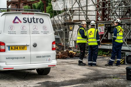
Drones avoid the cost of other visual inspection methods such as helicopters and the health and safety risks associated with scaffolding and sky-lifts. Using fully qualified and trained UAV pilots, along with structural engineers and visually qualified surveyors, we can undertake inspections within the most challenging of environments.
Drone Inspection UK & Europe
We have operating centres in Cardiff and Newport in South Wales, Corston in South West England and Gdańsk in Poland. This enables Sutro to operate drone inspection services for our clients throughout the UK and Europe. With easy access to the whole of the UK and Europe from Cardiff, Bristol and Heathrow Airports, we respond quickly and deliver industry-leading results.
In the UK and Europe, any individual conducting a visual inspection must be professionally trained. These individuals’ training includes academic qualifications and relevant experience, hazard identification, emergency procedures, information technology, and fire protection and prevention.
We are an ISO 45001 accredited organisation.
Similarly, as drone use in the UK and Europe is growing, there are select qualifications required for flying drones. Prior to partaking in an inspection, any individual piloting a drone between 250g and 20kg is required to obtain a certificate of registration from the Civil Aviation Authority (CAA), display his or her registration number on the drone, and have obtained an acknowledgement of competency from the CAA.
Our UAV pilots at Sutro meet these standards and are highly experienced, providing you with the necessary confidence that we will conduct your remote infrastructure drone inspections with caution and efficiency.
Drone Inspection FAQs
What is a drone inspection?
A drone inspection is a type of inspection that involves the use of drones also known as, unmanned aerial vehicles (UAVs), to gather visual data and information about a specific area or object. Drone inspections are typically conducted for industrial or commercial purposes, they can be used to inspect structures such as buildings, bridges, power lines, pipelines, and other infrastructure.
Drones are equipped with high-resolution cameras, sensors, and other equipment to capture images and data from different angles and perspectives. The drone can fly over or around the target area, providing a comprehensive view of the structure, and enabling the inspector to identify any potential issues or areas of concern.
Drone inspections offer several advantages over traditional inspection methods, including faster and more cost-effective inspections, improved safety for inspectors, and more accurate and detailed data. They can also be used to inspect areas that are difficult or dangerous to access using traditional methods, such as high-rise buildings, offshore oil rigs, or remote wilderness areas.
Overall, drone inspections are an innovative and effective way to conduct inspections, and they are becoming increasingly popular across a wide range of industries and applications.
Can drones perform thermal inspections?
Yes, drones can perform thermal inspections. In fact, drones with thermal imaging cameras are changing the face of industrial and energy inspection. The latest drone models are fitted the thermal imaging technology that allows us to identify faults in a range of structures including solar farms, power lines, wind turbines, bridges and roofs.
Thermal imaging drones can uncover hidden problems by comparing temperatures over large areas. Thermal cameras let drone operators see the invisible heat radiation that is emitted or reflected by all objects, regardless of lighting conditions. Unusual temperatures can indicate potential problems that need to be investigated further. For example, an aerial inspection using thermal imaging can identify areas of unexpected heat loss due to air leaks or water damage.
Do drones have night vision?
Not all drones have night vision fitted as standard. Those that do allow drone operators to record images or video in low light or complete darkness. There are three types of night vision drones, ones with low light cameras, infrared cameras and thermal cameras.
Low-light camera drones are fitted with large camera sensors and wide aperture lenses that allow them to make the most of the limited light available to create the image.
Infrared camera drones pick up infrared light which is invisible to the human eye. Detectors in the infrared camera capture a range of invisible energy emissions and then express each wavelength through a range of corresponding colours.
Thermal camera drones don’t require any light at all. Rather, they rely on thermal energy that is given off or reflected by objects.
Do drones show up on radar?
Radar can pick up drones. Radar detects objects by emitting radio waves in short pulses. If this signal hits an object, it bounces back to the radar antenna. The ability of radar to detect drones depends on the size of the drone and whether the radar antennae has been programmed to identify drones.
Latest Drone Inspection blog posts
Contact us to arrange a site survey, specific to
your maintenance requirements.
Find out how our access solutions can offer you cost efficiency whilst ensuring quality and safety.
0800 069 9395
Frazer Building
126 Bute Street
Cardiff
CF10 5LE


Cut Inspection Time 80%: Elios 3 Wind Turbine Blade Technology
How UAVs are transforming the energy sector: Insights and innovations
Addressing hidden inspection challenges with Elios 3’s radiometric thermal imaging
Transforming healthcare logistics with drones: a game-changing partnership
2024 Highlights
UAVs in water quality monitoring
The Role of Drones in Industrial Service and Safety Operations
Adam Viney – UAV Operations Manager shares his six key insights on the future of UAV technology in industrial inspections
Understanding LiDAR Technology in the Elios 3 UAV
Advancements in UAV Technology: Revolutionising Wildlife Research
Drone Inspections in the Oil and Gas Industry
Meet Adam Viney, UAV Operations Manager
Elevating your inspections with our NEW Elios 3
How are drone inspections used in the renewable energy sector?
UK Civil Aviation Authority unveils 2040 airspace overhaul
Revolutionising the UK Public Sector with Drone Technology
Connecting Europe through innovation and expertise
The future of logistics
Asset monitoring with cutting-edge inspection services
Navigating Complex Projects with Ease: Sutro’s Turnkey Methodology
Drone technology advancements in infrastructure inspections
Drones and Networking in Lausanne
The Soaring Commercial Drone Market
International Women’s Day
Amazon Prime Air Set to Take Flight in UK, 2024
How we partner with the Public Sector
Thriving UK Renewable Energy Sector
Drone Inspection Case Study – Sutton Bridge Power Station
What drones are used for inspections?
Green Energy Plant Power Outage
Internal Drone Inspection
The Ultimate Drone Inspection Tool